National Autonomous Technologies Data Platform (NATDaP)
Project Description:
The National Autonomous Technologies Data Platform (NATDaP), a Science Foundation Ireland Research Infrastructure Programme, will provide valuable open Autonomous Technology data (including driverless vehicles, A.I., robotics and drones) from collaborating Higher Education Institutes across Ireland, which can be accessed by a much wider community, including researchers and industry collaborators. The programme ensures Irish researchers have the capacity to apply for international funding opportunities including the Horizon 2020 funding calls. Additionally, the programme facilitates inter-institutional sharing of national research infrastructure, especially for Institutes of Technology, as well as effective research partnership with industry through collaborative initiatives. NATDaP comprises research infrastructure procured by four institutions to support research in autonomous vehicles and mobile robots.
1. MU
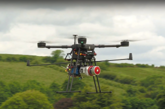
This research infrastructure consists of robotic platforms (Drones, Unmanned Ground Vehicles - UGVs, Autonomous Vehicles) and sensors (Optical, LiDAR & Navigation) enabling data to be acquired from the air and on the ground. A cloud platform will store and index data, enabling discovery and wider exploitation by Researchers, Government Bodies and Industry alike.
2. NUI Galway
The Connaught Automotive Research (CAR) Group in NUI Galway’s School of Engineering is active in the development of technology for connected and autonomous vehicle (CAV) applications. The fixed infrastructure consists of a set of sensors and associated embedded/edge computing and communications interfaces, located at key junctions and other locations on the campus. This will allow the collection of large amounts of data in a comprehensive set of scenarios with different configurations of road users typically found on campus (diverse traffic types, pedestrians, cyclists etc).
3. UCC
Experimental infrastructure to analyse the performance of vehicular communications (V2V or V2I) to meet the quality of service (QoS) requirements of future vehicular services in a variety of environments. Applications can include safety and traffic efficiency but can also include enhanced services such as cooperative awareness. The equipment includes wireless ITS-G5 and cellular V2X equipment, both on board-units (OBUs) and Roadside Units (RSUs) as well as experimental mmWave equipment.
4. MTU - Institute of Technology Tralee:
Modular manufacturing testbed to service the trialling & R&D needs of the Irish manufacturing sector. Equipment will allow IMaR to engage, research, develop and demonstrate the concepts of flexible modular manufacturing with AiVs with potential tech users in the Irish industrial manufacturing sector.
“Autonomous technologies offer huge societal and economic opportunities to Ireland. We are only beginning to see the practical applications this technology can provide. This investment will mean that not only can we create very real national capacity in this field but that we can ensure the opportunities have a much broader impact. This partnership with Maynooth University, the National University of Galway, the Institute of Technology Tralee, University College Cork and the SFI Research Centre LERO is an example of how cross-institute partnership will augment our national capability in autonomous technologies. Investments like this will ensure that Ireland can continue to compete at a global level, working in partnership with the leaders in industry and securing funding from programmes such as Horizon 2020.” Dr Timothy McCarthy, Maynooth University.
Usage and Accessibility:
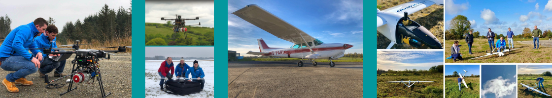
This Science Foundation Ireland Research Infrastructure Programme provides cutting edge infrastructure for the performance of high quality, impactful and innovative research. Many of the airborne sensors and equipment are available for use by academia and industry through a service agreement with GeoAerospace who operate various aerial platforms (drones/aircraft) and sensors on behalf of the University, providing specialised data-acquisition and post-processing services for academia, government agencies and industry. The available equipment, purchased under Science Foundation Ireland Research Infrastructure programme 18/RI/5810, includes the following:
- Robotnik Automation autonomous 4-wheel drive passenger vehicle with multiple sensors for autonomous navigation.
- Robotnik Automation autonomous lightweight 4-wheel drive platforms with associated LiDAR sensors and robotic arms.
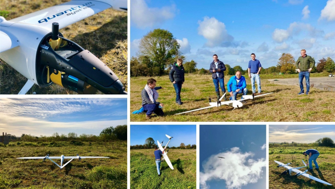
- Quantum Systems Tron F90+ fixed wing drone for large scale aerial surveys.
- Ouster compact LiDAR System for terrestrial mobile mapping.
- Zeb Horizon SLAM based LiDAR System for mobile mapping and aerial surveys.
- Specim AFX-10 hyperspectral sensor for light aircraft and drone surveys.
- Yellowscan UltraSurveyor LiDAR for aerial LiDAR surveys.
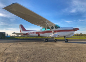
In addition to the above equipment, the NCG also secured a RIEGL LiDAR scanner in 2018 via an earlier SFI research infrastructure programme (16/RI/3705). This REIGL LiDAR scanner allows for large scale airborne data capture from a light aircraft and has been used to collect data pertaining to mapping and monitoring surveys for both for the research community as well as the semi-state and commercial sectors. This equipment is also available for use by industry and academia via the above-mentioned service agreement.