The AIRO 2016 SAPS Census Mapping Viewer will provide planners, policy-makers, researchers and the public with easy access to trends on population change in Ireland, demographic profiles of local areas, and many additional indicators on key themes to assist in understanding the social, economic and environmental characteristics of Ireland today. Essentially a public good service, the AIRO project provides maps, data analysis, policy advice, and research and training. Working with both public and private sector organisations, AIRO deals with a wide variety of different types of information such as demographics, housing, wind energy, crime and cultural mapping amongst others.
Working in close collaboration with the Central Statistics Office (CSO) the team at AIRO have developed a very detailed national census mapping viewer for the Republic of Ireland. This toolkit provides a national level visualisation of more than 160 census variables at the Small Area (SA) geographical scale in Ireland.
You can access the AIRO 2016 Census SAPS Mapping Viewer here.
As with previous releases the CSO are now providing a lot more interpretation and analysis of results by incorporating illustrative presentations, thematic maps and easy to read commentary. For anyone involved in research, planning, policy making or indeed those just interested in demographics these are really excellent reference documents to use. Full results and summary descriptions of all CSO Census releases are available here: http://www.cso.ie/en/census/
The background mapping on our viewer is using Ordnance Survey Ireland MapGenie and enables users to get the best possible visual analysis of local areas. This is the authoritative background mapping for Ireland and is licensed for use under the new National Mapping Agreement.
All-Island Research Observatory
Toggle 
Themes and Variables
The AIRO mapping viewer displays the results from the 2016 Census and includes 160+ variables (raw counts, percentages, ratios) on the following themes:
- Population (Density, Population Change 11-16, 06-16, Age Cohorts, Dependency)
- Religion
- Nationality & Ethnicity
- Marital Status
- Irish Speakers
- Families and Lone Parents
- Housing (Type, Tenure, Age, Vacancy, Housing Characteristics - Water, Sewerage, Heating etc)
- Principal Economic Status
- Occupations
- Education Attainment
- Travel and Commuting
- Health
- Internet and Broadband
- Car Ownership
You can access the AIRO 2016 Census SAPS Mapping Viewer here.
Geographical Hierarchy
In a major advancement from previous mapping tools we have now introduced a unique ‘geographical hierarchy’ information tool that allows users to click on any area on the map to receive a complete and relevant profile through the entire planning geographical hierarchy.
For instance, clicking on the map will provide a data overview (count and rates) available at SA, ED, Municipal District, Local Authority, Strategic Planning Area, Regional Assembly and State. From our experience working with local authorities, LECP/LCDC teams and other evidence-based research groups this will prove to be extremely useful and an excellent way of comparing and contrasting local areas with appropriate geographical scales. Where possible we have also included as much time series data as possible.
Working with the Viewer and Creating Images
The Viewer is very easy to use. Simply click on the Layer List button at the bottom of the screen to choose your Theme and Variable of choice. You will then be presented with that variable as a percentage.
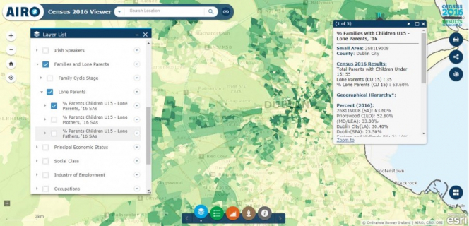
For instance, clicking on Families and Lone Parents, Lone Parents and % Lone Parents will show the % of all families with children under 15 that are lone parent families within a Small Area. If you click on a Small Area on the map, you will be then presented with a detailed geographical hierarchy of results from the Small Area to the State - as shown in the image below.
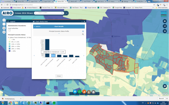
We have also configured the Chart Widget for a number of variables. This allows the user to create an on-the-fly analysis of underlying census data. The image below details a local level analysis of Labour Force rates in the Ballymun area of Dublin. Our configuration is based on a 'completely within' methodology - this means that all Small Areas that are completely with the study area are included in the final graphed outputs.